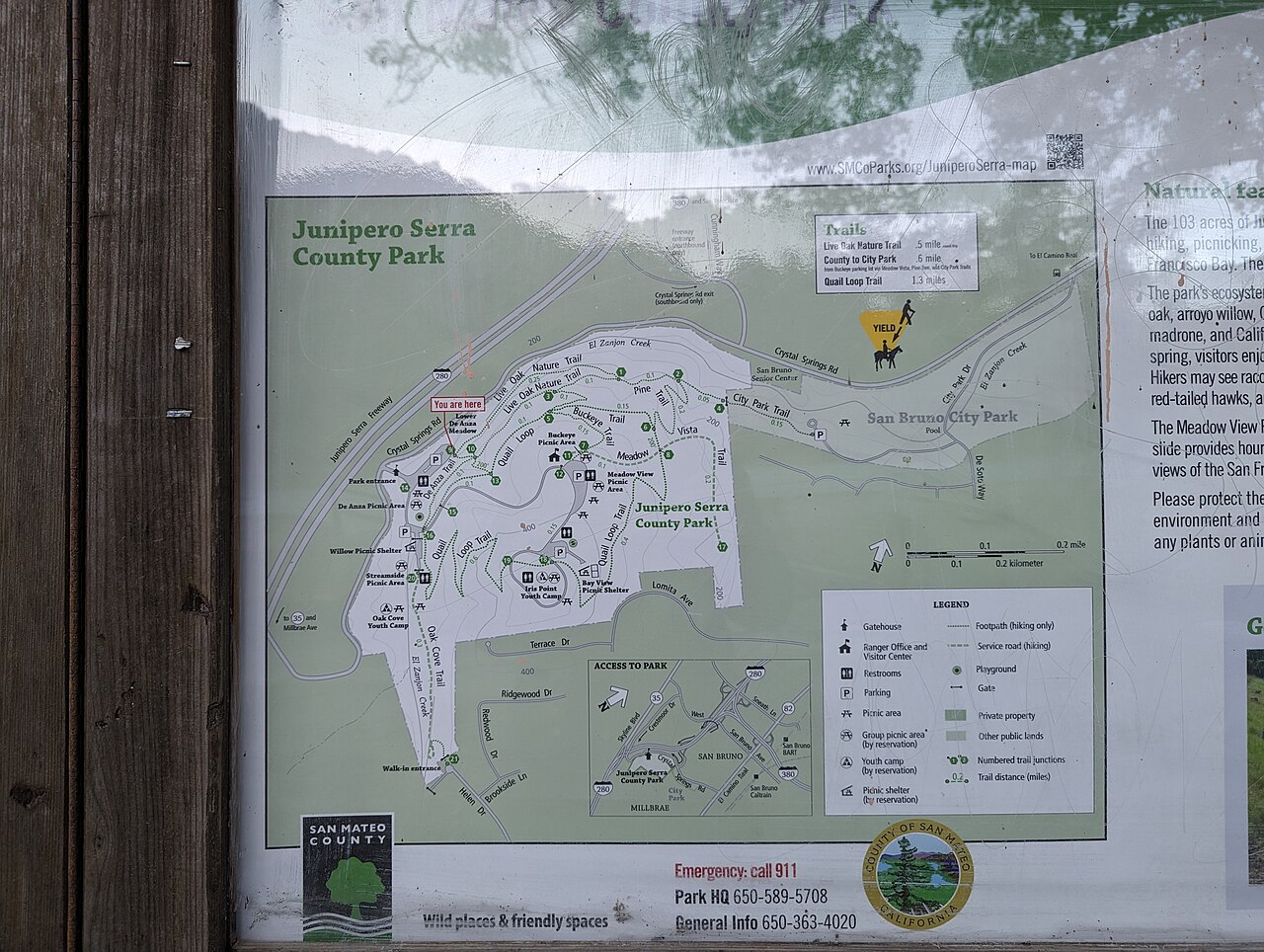
Junipero Serra Park
San Bruno, San Mateo County, CA
- Size
- 105 acres Source
- Managed by
- San Mateo County Parks
About Junipero Serra Park
A park behind Millbrae and San Bruno with panoramic Bay Area views, oak foothills, and spring wildflowers. Source
Nestled behind the cities of Millbrae and San Bruno, Junipero Serra Park affords a spectacular panorama of the Bay Area with unequaled views to San Bruno Mountain, San Francisco Airport, San Francisco Bay and Mount Diablo. Visitors are drawn to the Oak Foothill plant community, spring wildflowers, El Zanjon Creek, and the peaceful retreat the area affords from surrounding urban development.
Facilities
- BBQ Grills
- Drinking Water
- Picnic Area
- Playground
- Restrooms
Facility details: OpenStreetMap
Junipero Serra Park at a glance
- PParking · 6
- WCRestrooms · 5
- WDrinking water · 3
- Named trails · 7
Outline: CPAD. Points and trail lines: OpenStreetMap contributors. Not for navigation.
Trails
| Trail | Mapped length | Elevation | Surface & uses |
|---|---|---|---|
| Quail Loop Trail | 1.4 mi | 481 ft up & down249–460 ft | No bikesNo dogs |
| Live Oak Nature Trail Loop | 0.5 mi | 100 ft up & down189–252 ft | No bikesNo dogs |
| Oak Cove Trail | 0.3 mi | 68 ft up & down256–353 ft | No bikesUnpaved |
| Pine Trail | 0.3 mi | 113 ft up & down162–258 ft | No bikesNo dogs |
| Meadow Vista Trail | 0.3 mi | 168 ft up & down179–360 ft | |
| Buckeye Trail | 0.2 mi | 109 ft up & down241–368 ft | |
| De Anza Trail | 0.2 mi | 34 ft up & down230–261 ft | No bikesNo dogs |
Trail names and mapped lengths come from OpenStreetMap; lengths count only the part inside the park boundary. Up-and-down totals (climbing plus descent, one way) and elevation ranges are estimates from USGS 3DEP elevation (about 15 m grid) sampled along the mapped line. Use the official guide map for the route and current closures.
Getting to Junipero Serra Park by bus
- San Bruno Senior Center · at the park edge
Bus stops within about a quarter mile of Junipero Serra Park, mapped in OpenStreetMap. Check the transit agency for schedules.
Rules & reservations
Official park page- Dogs
Dogs must stay on leash (6 feet or less near others), no more than 3 per person, and out of playgrounds (county dog rules). Source
Map & directions
1801 Crystal Springs Rd. San Bruno, CA 94066
Nearby parks
Straight-line distanceContinue exploring
San Mateo County parks PlaygroundsSources & verification
Last verified: Oct 15, 2026- California Protected Areas Database (CPAD) 2026aname, county, agency, access, acres
- Dogs at San Mateo County Parksdogs
- San Mateo County Parks park pageofficial_url, address, description, fees
- Park hours pagehours
- San Mateo County Parks fees and chargesfees
- OpenStreetMap facilities and trailsfacilities.bbq-grills, facilities.drinking-water, facilities.picnic-area, facilities.playground, facilities.restrooms, trails
- U.S. Census Bureau place boundariescity
- OpenStreetMap: parking, restrooms, water, trailheads, trail lines, and bus stopsvisit
- Terrain Tiles elevation (USGS 3DEP), sampled every 20 m along OpenStreetMap trail linestrails.elevation
- Official park page (introduction excerpt)intro